Territory and Oklahoma Statehood Topographic Maps Held in the Research Center
- Addington 34-97 1916 30'
- Agra 35-96 1908 15'
- Agra 35-96 1908 15'
- Alikchi 34-95 1915 30'
- Alikchi 34-95 1926 30'
- Antlers 34-95 1912 30'
- Antlers 34-95 1912 30'
- Ardmore 34-97 1931 30'
- Ardmore 34-97 1931 30'
- Atoka 34-96 1914 30'
- Atoka 34-96 1901 30'
- Historical geology sheet
- Economic geology sheet
- Structure section sheet
- Columnar section sheet 1
- Columnar section sheet 2
- Bonham, TX 34-96 N.D.
Paris quadrangle included - Bristow 35-96 1948 15'
- Bristow 35-96 1948 15'
- Bristow 35-96 1948 15'
- Buggy creek 35-98 1893 15'
- Chandler 35-96 1905 15'
- Chandler 35-96 1907 15'
- Chickasha 35-97 1923 30'
- Chickasha 35-97 1923 30'
- Claremore 36-95 1914 30'
- Claremore 36-95 1916 30'
- Coalgate 34-96 1896 30'
- Coalgate 34-96 1900 30'
- Historical geology sheet
- Economic geology sheet
- Structure section sheet
- Coalgate 34-96 1914 30'
- Darlington 35-98 1893 15'
- De Queen, AR 34-94 1908-11 30'
- Denison, TX 33-96 1904 30'
- Denison, TX 33-96 1921 30'
- Denison, TX 33-96 1921 30'
- Edmond 35-97 1892 15'
- Edmond 35-97 1935 15'
- Foraker 36-96 1916 15'
- Foraker 36-96 1916 15'
- Fort Reno 35-98 1927 15'
- Fort Smith, AR 35-94 1931 30'
- Fort Smith, AR 35-94 1931 30'
- Gainesville, TX 33-97 1930 30'
- Guthrie 35-97 1892 15'
- Hennessey 36-97 1893 15'
- Hominy 36-96 1912 30'
- Kaw 36-96 1935 15'
- Kiefer 35-96 1914 15'
- Kiefer 35-96 1916 15'
- Kiefer 35-96 1916 15'
- Kiefer 35-96 1916 15'
- Kingfisher 35-97 1915 30'
- Kingfisher 35-97 1915 30'
- Kingfisher 35-97 1915 30'
- Lacey 35-98 1893 15'
- Lukfata 34-94 1917 30'
- Lukfata 34-94 1917 30'
- Luther 35-97 1909 15'
- Luther 35-97 1909 15'
- Map of the State of Oklahoma 1914 Oklahoma Geological Survey
- Maud 35-96 1907 15'
- Maud 35-96 1908 15'
- Maud 35-96 1908 15'
- McAlester 34-95 1909 30'
- McAlester 34-95 1909 30'
- McAlester 34-95 1909 30'
- McAlester 34-95 1924 30'
- McComb 35-97 1910 15'
- McComb 35-97 1941 15'
- McComb 35-97 1941 15'
- Montague 33-97 1905 30'
- Montague 33-97 1920 30'
- Moore 35-97 1892 15'
- Moore 35-97 1934 15'
- Mulhall 36-97 1893 15'
- Muskogee 35-95 1905 30'
- Muskogee 35-95 1910 30'
- Muskogee 35-95 1929 30'
- Muskogee 35-95 1929 30'
- Norman 35-97 1893
- Nowata 36-95 1914 30'
- Nowata 36-95 1914 30'
- Nowata 36-95 1914 30'
- Nowata 36-95 1932 30'
- Nuyaka 35-96 1914 30'
- Nuyaka 35-96 1914 30'
- Okmulgee 35-95 1925 30'
- Okmulgee 35-95 1925 30'
- Okmulgee 35-95 1925 30'
- Omega 35-98 1893 15'
- Ottawa County 36-94 1927
- T28N, R23E sec. 1-36
- T28N, R22E sec. 1, 12-3, 24-5, 36
- Ottawa County 36-94 1927
- T29N, R22E sec. 13, 14, 23-6, 35-6
- Ottawa County 36-94 1927
- T29N, R23E sec. 13-36
- Ottawa County 36-94 1927
- T29N, R24E sec. 13-36
- Pauls Valley 34-97 1916 30'
- Pauls Valley 34-97 1939 30'
- Pawhuska 36-96 1923 30'
- Pauls Valley 1898 34-97 30'
- Perkins 35-97 1909 15'
- Perkins 35-97 1909 15'
- Platt National Park, Murray County, OK
34-96 1909 - Platt National Park, Murray County, OK
34-96 1909 - Poteau Mountain, AR 34-94 1924 30'
- Pryor 36-95 1896 30'
- Pryor 36-95 1896 30'
- Pryor 36-95 1896 30'
- Quanah Mountain 34-98 1937
- Red Oak 34-95 1940 15'
- Rush Springs 34-97 1922 30'
- Sac and Fox 35-96 1906
- Sallisaw 35-94 1911 30'
- Sallisaw 35-94 1911 30'
- Sallisaw 35-94 1911 30'
- Sallisaw 35-94 1911 30'
- Sallisaw 35-94 1951 30'
- Sans Bois 35-95 1909 30'
- Sans Bois 35-95 1909 30'
- Seminole 35-96 1895-6 30'
- Seminole Prague 35-96 1896 30'
- Shawnee 35-96 1909 15'
- Shawnee 35-96 1909 15'
- Shawnee 35-96 1909 15'
- Shawneetown 33-94 1897-8 30'
- Sheridan 36-97 1893 15'
- Siloam Springs, AR 36-94 1899 30'
- Siloam Springs, AR 36-94 1899 30'
- Siloam Springs, AR 36-94 1920 30'
- Siloam Springs, AR 36-94 1920 30'
- Siloam Springs, AR 36-94 1920 30'
- Skedee 36-96 1929 15'
- Spencer 35-96 1935
- Stillwater 36-97 1893 15'
- Stonewall 34-96 1901 30'
- Stonewall 34-96 1928 30'
- Tahlequah 35-94 1898 15'
- Tahlequah 35-94 1910 30'
- Tahlequah 35-94 1910 30'
- Tahlequah 35-94 1910 30'
- Tahlequah 35-94 1910 30'
- Tahlequah 35-94 1927 30'
- Tishomingo 34-96 1903 30'
- Areal geology sheet
- Structure sections
- Columnar sections
- Tishomingo 34-96 1914 30'
- Tuskahoma 34-95 1928 30'
- Tuskahoma 34-95 1908 30'
- Tuskahoma 34-95 1909 30'
- Tuskahoma 34-95 1928 30'
- Vinita 36-95 1913 30'
- Vinita 36-95 1913 30'
- Wewoka 35-96 1925 30'
- Wewoka 35-96 1913 30'
- Wewoka 35-96 1949 30'
- Wichita National Forest and Game Preserve, Oklahoma Indian Meridian 34-98 1929
- Winding Stair 34-94 1909 30'
- Winding Stair 34-94 1909 30'
- Winding Stair 34-94 1909 30'
- Winding Stair 34-94 1928 30'
- Winding Stair 34-94 1928 30'
- Winding Stair 34-94 and 30'
- Winding Stair 34-94 1909 30'
- Winslow, AR 35-94 1913 30'
- Winslow, AR 35-94 1927 30'
- Winslow, AR 35-94 1927 30'
- Wyandotte 36-94 1907 30'
- Wyandotte 36-94 1921 30'
- Wyandotte 36-94 1921 30'
- Wyandotte 36-94 1921 30'
- Yale 36-96 1929 15'
- Yale 36-96 1929 15'
Map Index
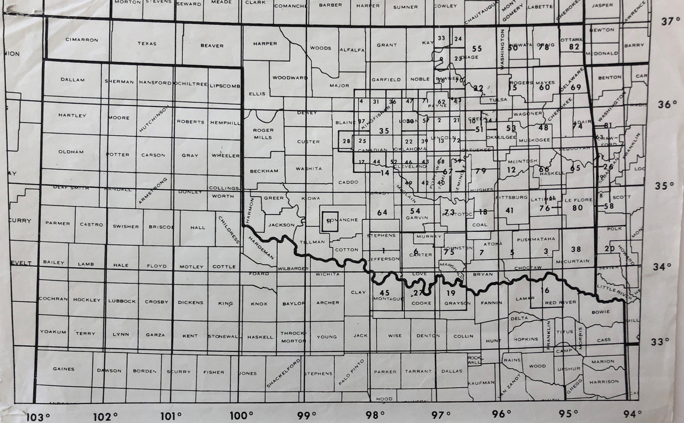
Maps Corresponding to the Map Index Image
1. Addington 1898, 1918 30' 34-97
2. Agra 1906 15' 35-45
3. Alikchi 1898 30' 34-95
4. Ames 1893 15' 36-98
5. Antlers 1896, 1911 30' 34-95
6. Ardmore 1898 30' 34-97
7. Atoka 1898 30' 34-96
8. Bates 1906 15' 34-94
9. Belford 1930 15' 36-96
10. Bristow 1915 15' 35-96
11. Cache 1937 15' 34-98
12. Canadian 1896 30' 35-95
13. Chandler 1905 15' 35-96
14. Chicasaw 1899 30' 35-97
15. Claremore 1897, 1914 30' 36-95
16. Clarksville 1940 30' 33-95
17. Cogar 1893 15' 35-98
18. Coalgate 1896 30' 34-96
19. Dennison 1899 30' 33-96
20. De Queen 1911 30' 34-94
21. Drumright 1906, 1929 15' 35-96
22. Edmund 1892, 1935 15' 35-97
23. Fairfax 1929 15' 36-96
24. Foraker 1914 15' 36-96
25. Fort Reno 1893, 1939 15' 35-98
26. Fort Smith 1887 30' 35-94
27. Gainesville 1898, 1902 30' 33-97
28. Geary 1939 15' 35-98
29. Greenwood 1906 15' 35-94
30. Guthrie 1892 15' 35-97
31. Hennessey 1893 15' 36-97
32. Hominy 1912 30' 36-96
33. Kaw 1930 15' 36-96
34. Kiefer 1914 15' 35-96
35. Kingfisher 1892 30' 35-97
36. Lovell 1893 15' 36-97
37. Loyal 1893 15' 35-98
38. Lukfaka 1896 30' 34-94
39. Luther 1907 15' 35-97
40. Maud 1907 15' 35-96
41. McAlester 1896, 1908 30' 34-95
42. McComb 1909 15' 35-97
43. McCloud 1907, 1928 15' 35-97
44. Minco 1893 15' 35-97
45. Montague 1898, 1904 30' 33-97
46. Moore 1892, 1934 15' 35-97
47. Mulhall 1893 15' 36-97
48. Muscogee 1898 30' 35-95
49. Norman 1893, 1934 15' 35-97
50. Nowata 1913 30' 36-95
51. Nuyaka 1896 30' 35-96
52. Oklahoma City 1893 15' 35-97
53. Okmulgee 1896 30' 35-95
54. Pauls Valley 1898 30' 34-97
55. Pawhuska 1909 30' 36-96
56. Pawnee 1930 15' 36-96
57. Perkins 1907 15' 35-97
58. Poteau Mountain 1887 30' 34-94
59. Prague 1906 15' 35-96
60. Pryor 1896 30' 36-95
61. Red Oak 1940 15' 34-95
62. Ripley 1929 15' 36-96
63. Rudy 1906 15' 35-94
64. Rush Springs 1898 30' 34-97
65. Sallisaw 1897, 1909 30' 35-94
66. Sansbois 1897, 1909 30' 35-95
67. Seminole 1896 30' 35-96
68. Shawnee 1907 15' 35-96
69. Siloam Springs 1899 15' 36-94
70. Skedee 1929 15' 36-96
71. Stillwater 1893 15' 36-97
72. Stroud 1906, 1927 15' 35-96
73. Stonewall 1895, 1898 30' 34-96
74. Tahlequah 1898 30' 35-94
75. Tishomingo 1898, 1908 30' 34-96
76. Tuskahoma 1897 30' 34-95
77. Van Buren 1906 15' 35-94
78. Vinita 1897, 1912 30' 36-95
79. Wewoka 1896 30' 35-96
80. Winding Stair 1898, 1909 30' 34-94
81. Winslow 1898 30' 35-94
82. Wyandotte 1907 30' 36-94
83. Yale 1929 15' 36-96