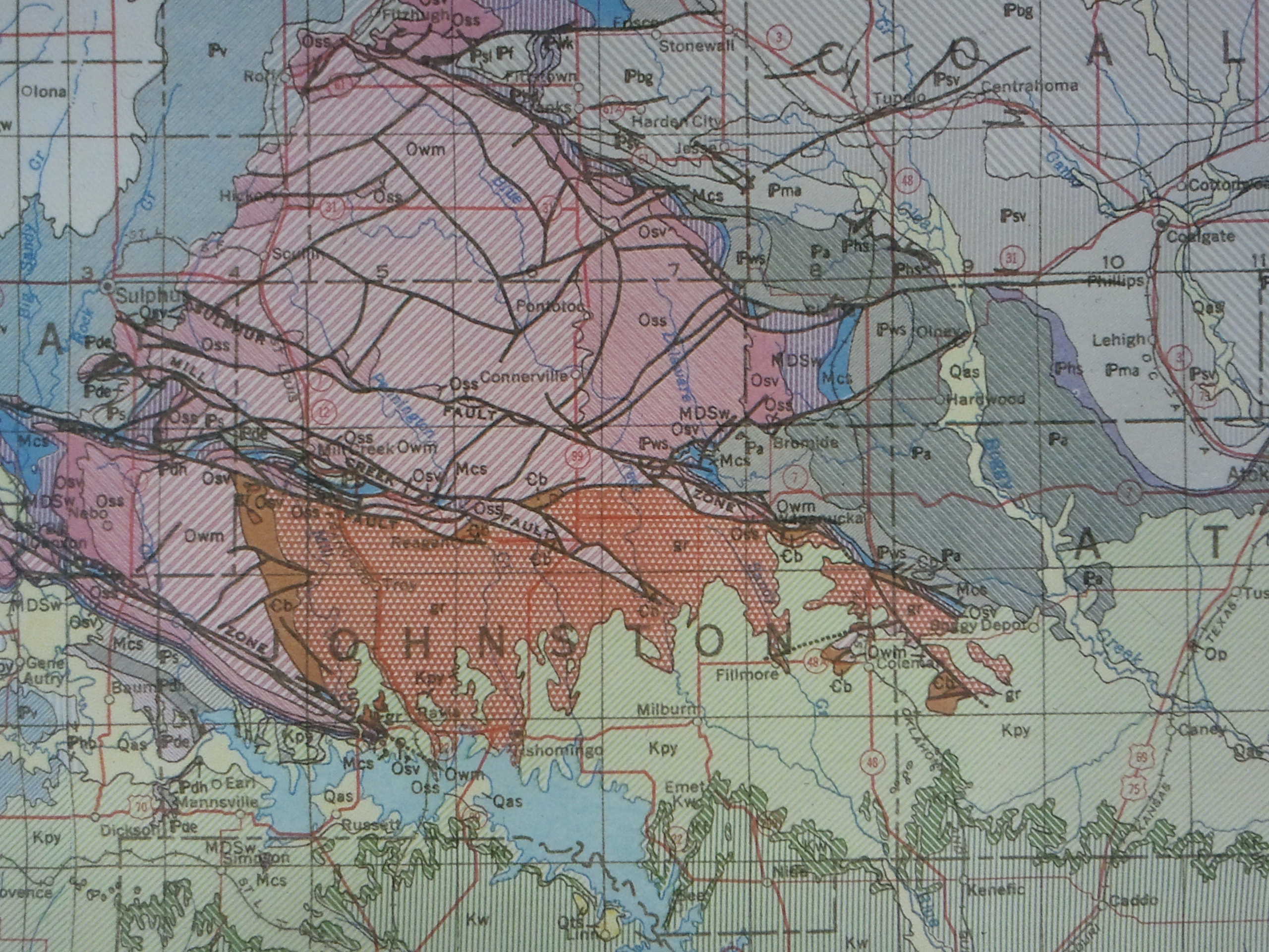
1954 Geologic Map of Oklahoma
Have a question? Ask us!
Research Center
Tulsa City-County Library
400 Civic Center Tulsa, OK 74103
918-549-7323
rcaskus@tulsalibrary.org
Research Center Geology, Oil, and Gas Collection
Tulsa is fortunate to have free access to a substantial geology research collection. Few public libraries in the nation can match the historical and current collections of Tulsa City-County Library. Petroleum geologists and consulting engineers are surprised to discover the jewels in the library's extensive holdings. Since many Oklahoma oil and gas companies also have operations outside the state, library resources cover not just Oklahoma, but some geology in other states.
Types of resources include:
Maps
Printed map collection (more than 35,000 maps) that includes:
- Geologic, topographic, hydrologic, oil, gas, mineral and other maps of select states
- Oil, gas and mineral maps of the United States
- Geologic highway maps of all states
Indexes to Maps
Indexes to maps included within U.S. Geological Survey, individual state geologic societies and Canadian publications.
Bulletins, Circulars, Investigations, Surveys, Papers, Guidebooks, Memoirs, Open-File Reports
National, state, and foreign literature on oil, gas and minerals includes publications of:
- U.S. Geological Survey
- Oklahoma Geological Survey
- Geological Survey of Canada
- U.S. Bureau of Mines (limited)
- Rocky Mountain Association of Geologists
- Texas University, Bureau of Economic Geology
- Various other state geological surveys
Geological Maps Basics
What are Geological Maps?
Most types of maps show man-made or natural features found on the earth's surface. Geologic maps are different from other maps since they typically show what is beneath the surface of the earth. Geology itself is the study of the earth and its history. Thus, geologic maps are used to present, among other things, formations of rocks and minerals, underground liquids and gases, and the movements and changes of the earth that occur over time.
Geologic maps serve an important purpose since, as stated by the United States Geological Survey (USGS), "the geology of an area has a profound effect on many things, from the likelihood of landslides, to the availability of groundwater in wells, from the amount of shaking suffered in an earthquake, to the presence of desirable minerals, from the way the landscape is shaped to the kinds of plants that grow best there. Understanding the earth underneath is the first step in understanding the world around us."
Map Reading Tips
The USGS has detailed information on reading geologic maps. Some of the basic things to remember are:
- A base map, which is a regular map, is printed under the geologic map in light colors to help orient the user.
- Look for a map key to identify symbols and colors used in the map. Sometimes the key is on a separate map sheet if it is extensive.
- Letters on the map refer to the age and name of the particular geologic unit.
- Lines on the map represent contact between geologic units. The shorter the dashes in the line, the more uncertain the location of the units.
- Short lines with numbers are used to show the angle and direction of tilted rock beds that have been thrust up unevenly.
Geological Map Series
The Research Center's Geological Map Series Indexes
The Tulsa City-County Library's Central Library has geological maps on the state, national, and international levels. These maps, which are mainly published by state or national geological societies, are located in the Central Library's Research Center.
- Levorsen Series Maps Index
- North American Geological and Mineral Maps Index
- United States Geological and Mineral Maps Index
- GSA Map and Chart Series
- Oklahoma Geological and Mineral Maps Index
- Oklahoma GM (Geological Maps) Series Maps Index
- Oklahoma HA (Hydrologic Atlas) Series Maps Index
- Tulsa's Physical Environment
- Surface Geology and Bouguer Gravity of Tulsa County, Oklahoma.
- General Soil Map of Tulsa County, Oklahoma, and Environs.
- General Construction Conditions At a Glance, Tulsa County, Oklahoma, and Environs.
- Locations of All Known or Reported Oil Wells, Gas Wells, and Dry Holes Drilled in Tulsa County and Adjacent Portions of Creek, Osage, Rogers, and Wagoner Counties, Oklahoma Prior to January 1, 1971.
Map Indexing, Ordering, and Downloading
Finding and Obtaining Maps
State geological map indexes, found in the vertical file drawers on the third floor in the Research Center, typically show a map divided into areas boxed off with colored borders. The colors sometimes indicate the scale of the maps while the numbers in each boxed-off area correspond to a numbered key showing the appropriate map source. Other indexes may be available, but it varies from state to state.
State geological publications catalogs can be helpful in determining what publications are available and, if we do not have them, how to order them. To find these, check the vertical files beneath the geological map index drawer. Each state will differ in the types of catalogs it offers. Oklahoma puts out special publications which have year-by-year indexes and bibliographies. When searching the alphabetical indexes, use key geological features, map series names, or the term 'counties.'
Publications of the U.S. Geological Survey is an annual catalog of all of the USGS publications grouped by type of publication and indexed by subject and author. When looking for maps in the subject index, search by state, type of map, or the word 'maps.' An abbreviations list is located at the front of the alphabetical index to identify the series or type of publication containing the information. The Research Center has these in print dating back to 1879. As of January 2004, the printed version of the catalog of publications of the U.S. Geological Survey was discontinued and made available online only.
Online indexing, ordering, and downloading is also available through the USGS. The National Geologic Map Database (NGMDB) allows searching by place and feature names or even by lithologic and geochronologic unit names. The USGS in its Geologic Maps page offers a link to the USGS Store where you can find maps by purpose. To find some of the newest publications, check the Publications Warehouse. Other useful links are given for state geological surveys. You can use these sites to find publications and ordering or downloading information for maps issued by agencies other than the USGS.
Geological Websites
Delve more into geology with these geological Websites
Oklahoma Geological Survey Mapping
Many Oklahoma Geological Survey maps and other publications are available online. Educational programs and publications abound here as well.
USGS Education and Outreach
This USGS site is rich in learning resources for children, educators, and the general public. Educators can find teaching resources divided up by primary, secondary and undergraduate levels. For more fun at school, check out the Schoolyard Geology. More geological information than you can imagine is available in the fact sheets which are keyword searchable.
USGS Geology in the Parks
This site contains basic explanatory information about geologic maps and about the impressive geologic formations found in some of our national parks. The Basics provides an introduction to geology and geologic maps, gives a glossary of terms, and links to some educational resources. In another section titled More, discover how formations such as sand dunes, caves, and glaciers formed. For a detailed look at some of the geologic wonders within our national parks and the forces that worked on them, delve into the Park Geology section. This site provides a wealth of information for the beginning geologist.
USGS Geology Research and Information
This site provides a gateway into the USGS world of geology. Some of the links take you into the realm of volcanoes, earthquakes and landslides, while others explore our mineral and energy resources. Check out information on our continually changing earth, our marine and coastal areas, or reach out into our solar system with the astrogeology page. The USGS also provides links at the bottom of their site for searching their own publications as well as making connections to partnering agencies.
USGS National Cooperative Geologic Mapping Program
Find an introduction, some history, and techniques of geologic mapping under "What's a Geologic Map?"
Worldwide Geological Surveys
Geoscience Professional Societies & Organizations
Find worldwide geological organizations in these sites.