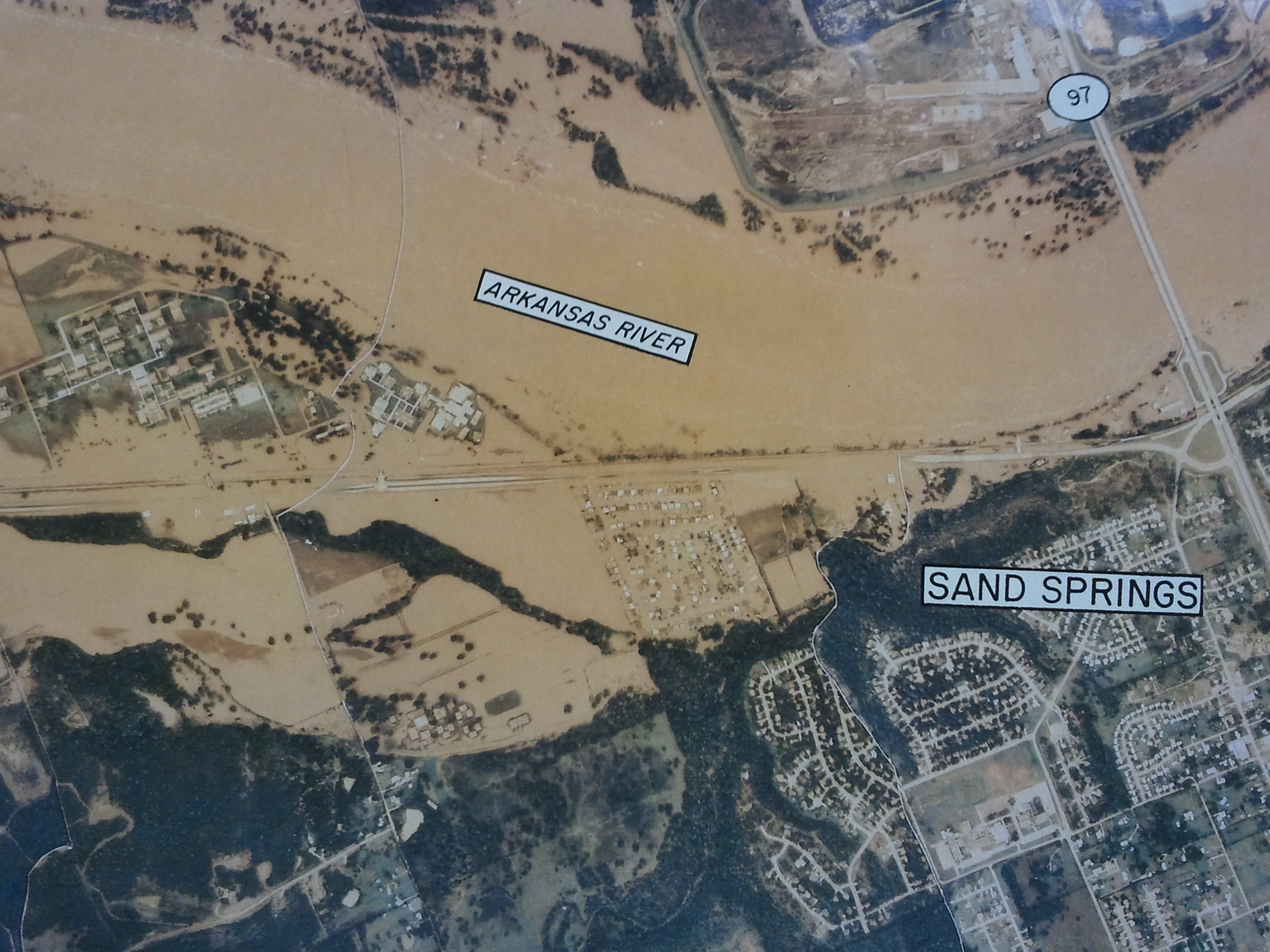
US Army Corps of Engineers' aerial photograph of flooded areas in Tulsa's 1986 flood
Have a question? Ask us!
Research Center
Tulsa City-County Library
400 Civic Center Tulsa, OK 74103
918-549-7323
rcaskus@tulsalibrary.org
Tulsa City and County Floodplain Maps
The city of Tulsa has a number of flood resources on their website from flood safety to flood history to flood insurance. They provide their widely requested Regulatory Floodplain Map Atlas on their site as well.
We carry the paper version of this map and keep it back historically.
Another publication we carry in paper is the Tulsa Public Works Department's "City of Tulsa: A General Guide to Regulatory Floodplains." The city mentions this in their Flood Insurance site and we keep both current and historical releases of this title.
Other 2017 city pamphlets we have copies of include:
- 2017 Repetitive Loss Area Notice
- Flood Hazard Information About Your Property
- Flood Risk in Tulsa: Are You Prepared?
- Flood Risk in West Tulsa
The City of Tulsa website has a 2023 Repetitive Loss Area Notice
On the county level, INCOG includes access on their site to the Tulsa County Floodplain Map.
Tulsa Federal Floodplain Maps
FEMA (Federal Emergency Management Agency) has a Map Service Center online where you can type in your address to bring up the FIRM (Federal Insurance Rate Map) flood map for your area.
The Research Center also has paper copies of the basic FIRM floodplain maps for Tulsa County.
To see known areas prone to flooding in Tulsa, view NOAA's Tulsa Flood Prone Areas map.
Flood Publications
Elevating Your House
Federal Emergency Management Agency
Answers to Questions About the National Flood Insurance Program
Federal Emergency Management Agency
Answers to Questions About Substantially Damaged Buildings
Federal Emergency Management Agency
Design Guidelines for Flood Damage Reduction
Federal Emergency Management Agency
Elevated Residential Structures
Federal Emergency Management Agency
Flood Insurance Manual
Federal Emergency Management Agency
From Harm's Way
City of Tulsa
From Rooftop to River: Tulsa's Approach to Floodplain and Stormwater Management
City of Tulsa
Check out a copy.
Guide to flood maps : how to use a flood map to determine flood risk for a property
Federal Emergency Management Agency
Homeowner's Guide to Retrofitting: Six Ways to Protect Your House From Flooding
Federal Emergency Management Agency
Managing Floodplain Development in Zone A Areas
Federal Emergency Management Agency
Hazard Mitigation Planning for Local Communities
Federal Emergency Management Agency
Protecting Building Utilities from Flood Damage
Federal Emergency Management Agency
Protecting Manufactured Homes from Floods and Other Hazards
Federal Emergency Management Agency
National Disaster Recovery Framework
Federal Emergency Management Agency
Repairing Your Flooded Home
Federal Emergency Management Agency and American Red Cross
Historical Tulsa Floodplain Maps
The Research Center houses many Tulsa city and county flood maps, even including historical maps like:
- Areas Flooded on May 27, 1984 in Tulsa Metropolitan Area
- Flood of May 26-27, 1984 in Tulsa, Oklahoma
- Tulsa Metropolitan Area: A General Guide to Flood Plain Areas of Local Streams
- Water Management Analysis Report: Flood of September-October 1986