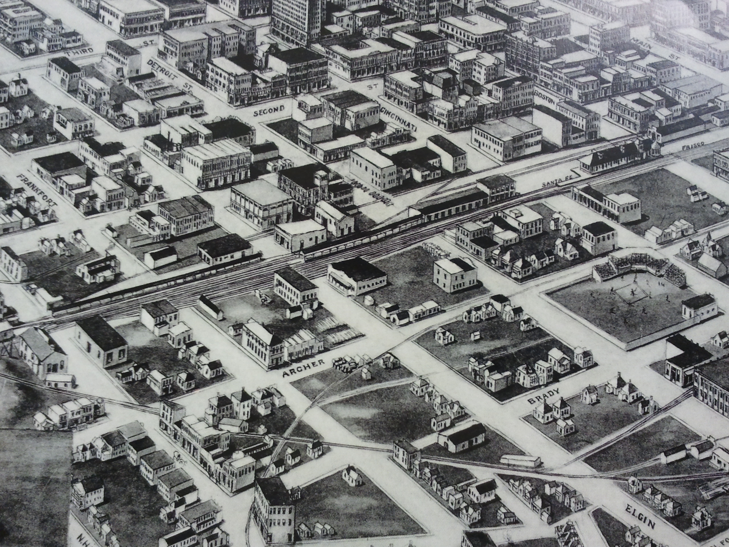
Aero View of Tulsa, 1918; drawn by T. M. Fowler; Oklahoma Historical Society Research Division
Have a question? Ask us!
Research Center
Tulsa City-County Library
400 Civic Center Tulsa, OK 74103
918-549-7323
rcaskus@tulsalibrary.org
Digitized Maps Collection
Digitized Maps Collection
In our TCCL digital collections, we have Tulsa County aerial map imagery from the 1950s and 1960s. Some other miscellaneous maps that are available in this digital map collection include Tulsa and a few surrounding city enumeration district maps, territory maps, a Tulsa sanitary sewer system plan, and a treasure hunter’s map among others.
For easier viewing on a larger platform, we have a Map Table, a horizontally mounted touchscreen monitor, with online access to our digital maps and other online map collections.
General Highway Maps for Counties in Oklahoma
1980's maps from the Oklahoma Department of Transportation, Planning Division
- Adair 1983
- Alfalfa 1983
- Atoka (2 sheets) 1984
- Beaver (2 sheets) 1984
- Beckham (2 sheets) 1984
- Blaine 1989
- Bryan (2 sheets) 1988
- Caddo (2 sheets) 1983
- Canadian 1989
- Carter 1987
- Cherokee (2 sheets) 1985
- Choctaw 1983
- Cimarron 1983
- Cleveland 1988
- Coal 1985
- Comanche 1983
- Cotton 1984
- Craig 1983
- Creek (2 sheets) 1983
- Custer 1988
- Delaware (2 sheets) 1985
- Dewey 1983
- Ellis 1983
- Garfield (2 sheets) 1983
- Garvin (2 sheets) 1986
- Grady (2 sheets) 1984
- Grant 1989
- Greer 1983
- Harmon 1983
- Harper (2 sheets) 1989
- Haskell 1986
- Hughes 1985
- Jackson 1988
- Jefferson 1987
- Johnson (2 sheets) 1987
- Kay 1988
- Kingfisher 1989
- Kiowa (2 sheets) 1983
- Latimer 1988
- Le Flore (2 sheets) 1988
- Lincoln 1988
- Logan 1988
- Love 1987
- Major (2 sheets) 1989
- Marshall 1986
- Mayes 1986
- McClain 1986
- McCurtain (2 sheets) 1984
- McIntosh (2 sheets) 1987
- Murray 1988
- Muskogee (2 sheets) 1987
- Noble 1983
- Nowata 1988
- Okfuskee 1985
- Oklahoma 1989
- Okmulgee 1984
- Osage (4 sheets) 1985
- Ottawa 1988
- Pawnee (2 sheets) 1985
- Payne 1985
- Pittsburg (3 sheets) 1988
- Pontotoc 1986
- Pottawatomie 1986
- Pushmataha (2 sheets) 1984
- Roger Mills (2 sheets) 1988
- Rogers (2 sheets) 1991
- Seminole (2 sheets) 1986
- Sequoyah 1988
- Stephens 1984
- Texas (2 sheets) 1989
- Tillman (2 sheets) 1986
- Tulsa 1993
- Washington (2 sheets) 1988
- Washita 1983
- Woods (2 sheets) 1989
- Woodward (2 sheets) 1989
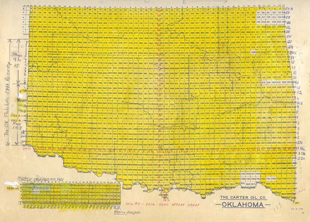
General Land Office (GLO) Plat Maps
What are GLO Plat Maps?
The Tulsa City-County Library Research Center at the Central Library houses in its map collection several sets of GLO Plat maps. These maps are hand-drawn and at their most detailed include trees, lakes, rivers, railroads, houses and fields of different types. They are arranged by township, range and section and are mainly used by surveyors and researchers.
The Tulsa City-County Library collection, consisting only of the plats, was donated to the library by Amerada Hess and the Carter Oil Company. The set of GLO Plats covers most of Oklahoma plus portions of some surrounding states.
Background
Public land surveys were placed under the direction of the principal clerk of surveys in the General Land Office (GLO) on July 4, 1836. The GLO continued to function for more than a century, until it was replaced by the Bureau of Land Management which was established on July 16, 1946.*
The tangible products of a public land survey are the field notes and the plat. The plat is the drawing that represents the lines surveyed, i.e. section boundary lines, subdivision lines of sections, lines of segregation such as mineral or other claim boundaries, etc. Many township plats are not strictly plats since they often include topographic and other mappable features.
Field notes provide a written description of the physical features of the area surveyed as well as a record of measurements and monuments.
GLO records for Oklahoma date back to July 25, 1870 when the first survey crews began work on lands in the Chickasaw Indian Nation near old Fort Arbuckle in what is now Murray County. These records are the original descriptions of the lands surveyed and do not show any personal ownership of land.
* Thompson, Morris M., Maps for America. I19.2:M32/12/897-979, p. 11.
Using the Index
To locate a specific map, you must know the township and range of the area in question. The cell in which the township and range meet provides the map number. If the cell is highlighted in yellow the library has the map.
The index below to the maps is available in the Research Center.
Oklahoma Late 1800s and early 1900s - original federal land surveys
Oklahoma Department of Libraries Collection
The Bureau of Land Management offers online availability for General Land Office Survey Plats and Field Notes.
Historical Oklahoma Highway Maps
The Oklahoma Department of Transportation's highway maps of Oklahoma back to the late 1910s
- The State of Oklahoma 1916; Department of Highways
- State-Wide System of Hard-Surfaced Roads Proposed for the State of Oklahoma by the Governor and the Seventh Legislature; April 5, 1919; Department of Highways of the State of Oklahoma (2 copies)
- State of Oklahoma Preliminary Designation of the State Highway System; August 28, 1924; State Highway Commission (2 copies)
- Oklahoma State Highway System; July 1, 1925; State Highway Commission
- Oklahoma State Highway System; May 1, 1926; State Highway Commission
- Oklahoma State Highway System; November 1, 1927; State Highway Commission
- Oklahoma State Highway System; July 1, 1928; Oklahoma State Highway Commission
- State of Oklahoma Department of Highways Map Showing Condition of Improvement of the State Highway System; January 1, 1929; State Highway Commission
- State of Oklahoma Department of Highways Map Showing Condition of Improvement of the State Highway System; March 1, 1930; State Highway Commission
- State of Oklahoma Department of Highways Map Showing Condition of Improvement of the State Highway System; July 1, 1931; State Highway Commission
- State of Oklahoma Department of Highways Map Showing Condition of Improvement of the State Highway System; December 1, 1931; State Highway Commission
- State of Oklahoma Department of Highways Map Showing Condition of Improvement of the State Highway System; June 1932; State Highway Commission
- State of Oklahoma Department of Highways Map Showing Condition of Improvement of the State Highway System; August 1933; State Highway Commission
- State of Oklahoma Department of Highways Map Showing Condition of Improvement of the State Highway System; February 1934; State Highway Commission
- State of Oklahoma Department of Highways Map Showing Condition of Improvement of the State Highway System and Landing Fields; October 1935; State Highway Commission
- State of Oklahoma Department of Highways Map Showing Condition of Improvement of the State Highway System and Landing Fields; May 1936; State Highway Commission
- State of Oklahoma Department of Highways Map Showing Condition of Improvement of the State Highway System and Landing Fields; April 1937; State Highway Commission
- State of Oklahoma Department of Highways Map Showing Condition of Improvement of the State Highway System; April 1938; State Highway Commission
- State of Oklahoma Department of Highways Map Showing Condition of Improvement of the State Highway System; April 1939; 20 miles to 1 inch; State Highway Commission
- State of Oklahoma Department of Highways Map Showing Condition of Improvement of the State Highway System; April 1940; 20 miles to 1 inch; State Highway Commission
- State of Oklahoma Department of Highways Map Showing Condition of Improvement of the State Highway System; April 1941; 20 miles to 1 inch; State Highway Commission
- State of Oklahoma Department of Highways Map Showing Condition of Improvement of the State Highway System; January 1942; 20 miles to 1 inch; State Highway Commission
- State of Oklahoma Department of Highways Map Showing Condition of Improvement of the State Highway System 1943; 20 miles to 1 inch; State Highway Commission
- State of Oklahoma Department of Highways Map Showing Condition of Improvement of the State Highway System; June 1944; State Highway Commission
- State of Oklahoma Department of Highways Map Showing Condition of Improvement of the State Highway System; May 1945; State Highway Commission
- State of Oklahoma Department of Highways 1947
- Map of Oklahoma’s State Highway System 1948 Oklahoma Department of Highways
- Map of Oklahoma’s State Highway System 1950 Oklahoma Department of Highways
- Map of Oklahoma’s State Highway System 1951 Oklahoma Department of Highways
- Map of Oklahoma’s State Highway System 1952 Oklahoma Department of Highways
- Highways of Oklahoma 1953 Oklahoma Department of Highways
- Highways of Oklahoma 1954 Oklahoma Department of Highways
- Highways of Oklahoma 1955 Oklahoma Department of Highways
- Oklahoma’s Highways 1956 Oklahoma Department of Highways
- Oklahoma Highways 1957 Oklahoma Department of Highways
- Oklahoma Road Map 1958 Oklahoma Department of Highways
- Oklahoma Road Map 1959 Oklahoma Department of Highways
- Oklahoma Road Map 1960 Oklahoma Department of Highways
- Oklahoma Road Map 1961
- Oklahoma 1962
- Oklahoma 1963
- Oklahoma 1964
- Oklahoma 1965
- Oklahoma 1966
- Oklahoma 1967
- Oklahoma 1968
- Oklahoma 1969
- Oklahoma 1970
- Oklahoma Department of Highways 1978 (includes townships and ranges) 8 miles to 1 inch
- Oklahoma Department of Highways 1978 North Half (includes townships and ranges) approx. 4 miles to 1 inch
- Oklahoma Department of Highways 1978 South Half and Panhandle (includes townships and ranges) approx. 4 miles to 1 inch
- State of Oklahoma (Township, Range, and Section Map) 3’X5’
- State of Oklahoma (Township, Range, and Section Map) 20”x35”
Historical Oklahoma Map Collection
The Research Center's miscellaneous collection of historical maps of Oklahoma excluding Tulsa
- 1 Oklahoma City Birds-eye View, 1890; sketched by T. M. Fowler; Oklahoma Historical Society Research Division
- 2 State of Oklahoma, 1907; 1 inch= 12 miles; drawn by Charles J. Helm; Oklahoma Historical Society Research Division; 2 copies
- 3 State of Oklahoma Counties and Vote for Secretary of State 1910, by Counties--To be Used for Tracing Political Lines; compliments Seth K. Cordon, Secretary State Election Board; E.C.D. Yarmett
- 4 Hunters’ & Fishermen’s Map of Oklahoma; 1940; 1 inch=30 miles; Tom Collins, Tulsa County Surveyor
- 5 General Highway Map, Muskogee County, Oklahoma; 1942; 1 inch=2 miles; 2 sheets; prepared by the Oklahoma State Highway Commission State-Wide Highway Planning Survey in cooperation with the Public Roads Administration, Federal Works Agency
- 6 Eufaula Dam and Reservoir (dam completed 1964); 1 inch= 4 miles; Eufaula Dam Association
- 7 Oklahoma; 1980; 1:500,000; prepared by Geography Division in cooperation with Data Preparation Division; U.S. GPO
Historical Tulsa & Oklahoma Maps
A separately housed collection of historical Tulsa and Oklahoma maps
- 1 (No title) Organization Chart, City of Tulsa, under Commission form of government
- 2 Map of Tulsa and Environs, Tulsa Engineering & Supply Co., circa 1920, on back: alphabetical listing of buildings, churches, streets & avenues, & additions, gift of Harold Sexton
- 3 1970 Census Tracts & Enumeration Districts, sheet 2 of 2, revised 2-15-71, Tulsa Metropolitan Area Planning Commission
- 4 Map of Oklahoma Territory, to accompany Annual Report of Governor of the Territory, 1900 (2 copies)
- 5 Map of Oklahoma Territory, to accompany Annual Report of Governor of the Territory, 1901 (2 copies)
- 6 Map of Oklahoma Territory, to accompany Annual Report of Governor of the Territory, 1903 (2 copies)
- 7 Map of Oklahoma Territory, to accompany Annual Report of Governor of the Territory, 1905 (2 copies)
- 8 Map of Oklahoma Territory, to accompany Annual Report of Governor of the Territory, 1906 (2 copies)
- 9 Map of Oklahoma Territory, to accompany Annual Report of Governor of the Territory, 1907 (2 copies)
- 10 Map of the Indian Territory showing Oklahoma Country, Rand McNally, 1889 reproduced in Tulsa Tribune, June 20, 1957
- 11 Historical Map of Oklahoma, Tulsa Daily World, June 26, 1932
- 12 Historical Map of Oklahoma, Oklahoma Natural Gas, copyright 1966 (3 copies)
- 13 Map of Oklahoma, Rand McNally, 1910, on back: alphabetical listing of Counties, Creeks, Mountains, Rivers & Towns, 1"=13 miles
- 14 Treasure Hunters Map of Oklahoma Ghost Towns, 1970, by Ken James, Thrifty Electronics, Inc. Also: Ghost Towns of Oklahoma, no date
- 15 Reproduction from the New-State Tribune of a January 2, 1908 hand-written letter to William Jennings Bryan, signed by Governor Charles Haskell & others
- 16 Oklahoma, County Subdivisions, Census Divisions & Places, 1970, U.S. Bureau of the Census, Department of Commerce
- 17 General Highway Map, Tulsa County, Oklahoma, 1972, County Engineer Floyd Oakley (2 copies)
- 18 Tom Meagher's Sketch Map of The Three Forks, no date
- 19 Oklahoma 1894, from American Scene, vol. 4, no. 4, 1962, pp. 55-56
- 20 Map of Oklahoma, Rand McNally, 1910, on back: alphabetical listing of Counties, Creeks, Mountains, Rivers & Towns, 1"=13 miles
- 21 Tulsa & Vicinity, 1929, Tulsa Free Press & Greater Tulsa Reporter, January 1998 (2 copies)
- 22 Historical Map of Ottawa County, Oklahoma, Ottawa County Historical Society, 1965
- 23 Tulsa & Northeast Oklahoma, 1928, Tulsa Chamber of Commerce tourist folder
- 24 City of Tulsa, Triangle Blueprint & Supply Co., 1929
- 25 Tulsa & Environs, from Burkhart's Tulsa City Directory, 1909
- 26 (1)Declaration of Independence
(2)Aero View of Tulsa, Oklahoma, 1918, drawn by T. M. Fowler, published by Fowler & Kelly - 27 Indian Reservations in the United States, 1966, U.S. Geological Survey
- 28 Native Tribes of North America, 1939, University of California, Map Series #13
- 29 Map Showing Indian Reservations in the United States West of the 83rdMeridian, 1879, The Norris Peters Co., Washington DC
- 30 Map Showing Indian Reservations Within the Limits of the United States, 1913, The Norris Peters Co., Washington DC
- 31 Civil War in Indian Territory 1861-1865, Oklahoma Department of Transportation, Historical Map Series, no date
- 32 Old Oklahoma and The Run of 1889, 1980 (2 copies)
- 33 Original Townsite, Tulsa, Okla., 1920, A. T. Thorne
- 34 Official Map of The City of Tulsa & Regional Area, 1929-30, Hamilton-Elliot Engineering Co.
- 35 Plan of Sanitary Sewer System, Tulsa, I.T., circa 1906
- 36 General Highway Map, Tulsa County, Oklahoma, 1958, revised 1963
Historical Tulsa Map Collection
The Research Center's historical Tulsa map collection
- 1 Map of Original Townsite Tulsa, Oklahoma; August 1915; 200 feet=1 inch; Office of City Engineer
- 2 Map of Tulsa, Oklahoma and Vicinity; 1915; drawn by J. Robert Burnham; Department of Commerce, Bureau of the Census
- 3 Aero View of Tulsa, 1918; drawn by T. M. Fowler; Oklahoma Historical Society Research Division
- 4 City of Tulsa Pocket Map; mid-1920s; drawn by Roy Gilmore; for sale by Tulsa Engineering & Supply Co.
- 5 Tulsa and Vicinity in 1929; reprinted in the Tulsa Free Press & Greater Tulsa Reporter,January 1998, page 15
- 6 Tulsa, Oklahoma; February 1930; revised July 1941; 1,000 feet=1 inch; drawn by C. K. L. (rest of name indecipherable); Office of the City Engineer (2 copies)
- 7 Map of the City of Tulsa, Oklahoma and Suburbs; pre-1952; 1 inch=1,000 feet; Triangle Blue Print & Supply Co.
- 8 Tulsa County Aerial Map print of Tulsa International Airport & Lake Yahola (T20N R13E sections 9,10,11,14,15,16,21,22,23) AR1VCT000010056; June 13, 1954; 1:17,000; USGS
- 9 City of Tulsa, Oklahoma; September 1, 1955; 2.5 inches=1 mile; Triangle Blue Print & Supply Co.
- 10 Map of the Oil Capital Tulsa, Oklahoma; 1955; drawn by Frank F. Pitezel
- 11 Proposed Inner Dispersal Loop; June 1957; 1 inch=400 feet; Tulsa Metropolitan Area Planning Commission
- 12 Tulsa and Perimeter Area Express Way System: A Part of the Official Master Plan; June 28, 1957; 1 inch= 3,000 feet; Tulsa Metropolitan Area Planning Commission
- 13 Street Map of Greater Tulsa, Oklahoma; July 1963; 2 inches=about 1 mile; by Roy Malernee & Jim Plummer; City Map Service
- 14 American Insurance Association Map of Tulsa, Oklahoma; September 1965; 3.25 inches=about 1 mile
- 15 This is Tulsa: The Oil Capital of the World; pre-1966; Tulsa Chamber of Commerce
- 16 Map of the Oil Capital Tulsa, Oklahoma; 1955, revised June, 25 1973; drawn by Frank F. Pitezel
- 17 Map of the Oil Capital Tulsa, Oklahoma; 1955, revised July 22, 1974; drawn by Frank F. Pitezel
- 18 Map of the Oil Capital Tulsa, Oklahoma; 1955, revised March 1, 1976; drawn by Frank F. Pitezel
- 19 Tulsa Urban Study Area Urban Development Map; pre-1980; ½ inch= 1 mile
- 20 Tulsa Aerial Map print of Tulsa International Airport; December 12, 1980; Aerial Photo Service
- 21 General Highway Map Tulsa County, Oklahoma; 1981; 1 inch=4 miles; Oklahoma Department of Transportation Planning Division; printed by the Topographic Engineering Co.
- 22 Tulsa County Corporate Limits; pre-1982?; ½ inch=approximately 1 mile; Tulsa Metropolitan Area Planning Commission
- 23 General Highway Map Tulsa County, Oklahoma; April 1983; ½ inch=approximately 1 mile; Aerial Data Service; scribed by Mike Snyder
- 24 City of Tulsa Official Map; July 1, 1983; 2 inches=1 mile; Office of the City Engineer
- 25 Central Business District; November 21, 1975, revised June 11, 1986; 1 inch=200 feet; Tulsa Urban Renewal Authority
- 26 General Highway Map Tulsa County, Oklahoma; drafted September 1982, revised February 1988; 1 inch=1 mile; Oklahoma Department of Transportation Planning Division
- 27 Street Map of Tulsa, Oklahoma and Vicinity; 1988; City Map Service
- 28 Central Business District; November 21, 1975, revised March 8, 1989; 1 inch=200 feet; Tulsa Urban Renewal Authority
- 29 City of Tulsa Official Map; October 1986, revised August 1989; 2 inches=1 mile; Office of the City Engineer
- 30 Metropolitan Tulsa Area Corporate Limits, Territorial and Jurisdictional Limits; February 1994; 1.25 inches=4 miles; INCOG
- 31 1995-’96 Tulsa, Oklahoma’s Commemorative Character Map; illustrated by Peggy Anderson; World Graphics Map Company
- 32 Metropolitan Tulsa Area Corporate Limits: Territorial and Jurisdictional Limits; March 2002; INCOG (2 copies)
Older Edition Oklahoma Topographic Maps
Superceded Oklahoma topographic maps
As the United States Geological Survey released updated versions of topographic maps in Oklahoma, the Research Center retained our earlier editions which now form this archival collection.
How to read the index
The entries list the map name, the latitude and longitude of the southeast corner of the map, the date that particular edition of the map was last published, and the scale of the map in minutes if it is not 7½ minutes.
Stillwater 36-97 1893 15'
Name of map: Stillwater
Latitude: 36 degrees north
Longitude: 97 degrees west
Date of map edition: 1893
Scale: 15 minutes = 1:62,500 (1 inch = approximately 1 mile)
Note: 30 minutes = 1:125,000
Occasionally, the map index may include a more detailed legal description for the maps including township, range, and section, as in the following example:
- Ottawa County 36-94 1927
- T29N, R23E sec. 13-36
Name of map: Ottawa County
Latitude: 36 degrees north
Longitude: 94 degrees west
Date of map edition: 1927
Township: 29 north
Range: 23 east
Sections: 13-36
Sanborn Maps 1867-1970
Oklahoma Sanborn Maps
In digital format, we subscribe to Oklahoma Sanborn Maps 1867-1970. These are maps created to assist fire insurance companies as they assessed the risk associated with insuring a particular property. Historical large-scale plans include the outline of each building, the size and shape, construction materials, heights, function of structures, and location of windows and doors. A printable Sanborn Legend is available. Tulsa’s maps fall between 1894-1962. Printed copies are available for viewing in our Oklahoma Collection on the 3rd floor of Central Library.
Territory & Early Oklahoma Statehood Maps
Indexes to our Indian and Oklahoma Territory & Early Oklahoma Statehood Map Collection
How to read the Index
The entries list the map name, the latitude and longitude of the southeast corner of the map, the date that particular edition of the map was last published, and the scale of the map in minutes.
Stillwater 36-97 1893 15'
Name of map: Stillwater
Latitude: 36 degrees north
Longitude: 97 degrees west
Date of map edition: 1893
Scale: 15 minutes = 1:62,500 (1 inch = approximately 1 mile)
Note: 30 minutes = 1:125,000
Occasionally, the map index may include a more detailed legal description for the maps including township, range, and section, as in the following example:
- Ottawa County 36-94 1927
- T29N, R23E sec. 13-36
Name of map: Ottawa County
Latitude: 36 degrees north
Longitude: 94 degrees west
Date of map edition: 1927
Township: 29 north
Range: 23 east
Sections: 13-36