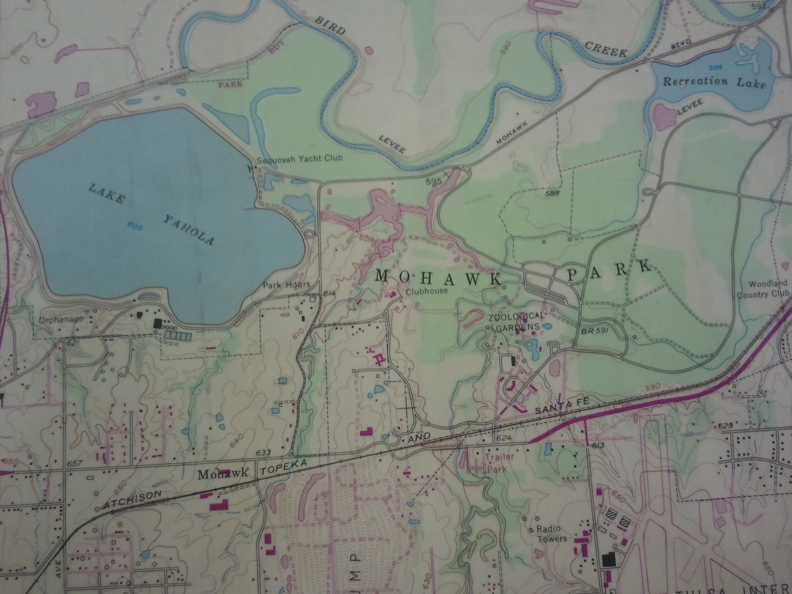
Topographic Map of Mohawk Park in Tulsa
Have a question? Ask us!
Research Center
Tulsa City-County Library
400 Civic Center Tulsa, OK 74103
918-549-7323
rcaskus@tulsalibrary.org
What are Topographic Maps?
Topographic maps (also called topo maps) are maps that illustrate the lay of the land. With the use of contour lines, these maps effectively depict hills, mountains, plains, and valleys. The United States Geological Survey (USGS), which publishes topographic maps, provides an explanation and history of these maps and information about the map-making process.
Features
Topo maps incorporate features such as contour lines, the magnetic north declination, roads, cities, railroads, pipelines, and fence lines, bodies of water, trees, wells, buildings, and cemeteries. These maps also include the latitude and longitude, and on most topographic series, the township and range. The more detailed series, 1:24,000 and 1:100,000 provide section numbers. The USGS details some of the features found on topographic maps.
Uses
In addition to finding out the general lay of the land and the highest and lowest spots in an area, topographic maps can be used for other purposes. Hikers and vacationers often use topos to plan their travels. Students can trace the path of a river, locate national parks, or search for particular landmarks. Genealogists often employ topographs to locate cemeteries, churches and schools.
According to the United States Geological Survey, topographic maps often are used for engineering, energy exploration, natural resource conservation, environmental management, public works design, commercial and residential planning, and outdoor activities like camping, and fishing.
Topographic maps can also help either to establish the legal description of a piece of land or to determine where a piece of property is located by means of a legal description. You can even use them to find out if there are any oil or gas wells on a particular property or to establish where certain pipelines, power lines, or railroads run.
Map-Reading Tips
An index to symbols used to read topo maps is available in the Research Center. The USGS provides a list and description of topographic map symbols as well.
To find adjoining maps look for the names of the neighboring maps at the sides and corners of the topo map you are viewing, or look at the chart near the bottom right hand corner that lists the names of the surrounding maps.
Latitude and longitude is located at each corner of a map and at intervals along the map's borders.
Township and Range, when used, are included on the 1:24,000 series, the 1:100,000 series, and the 1:250,000 series. Look along the map borders to find these numbers. Sections are only available on the most detailed maps, the 1:24,000 and 1:100,000 series.
Depending on the scale, section numbers will either be centered in each section or only labeled in the first and last section of each township and range. Each township and range is comprised of thirty-six sections that snake back and forth left to right and right to left rather than being lined up one series of numbers under another. The USGS provides more information about the township and range system.
Contour interval data can be found at the bottom of each map near the scale. Also, look for elevation figures within the contour lines on the map within your selected area. Periodic wider contour lines act as index lines to help determine elevations more easily. Some of the 1:500,000 state topographic maps include bathymetric lines or depth curves in bordering coastal waters.
For more help in reading topographic maps try checking out Reading Topographic Maps: Activities for Earth Science Teachers and Students by James R. Chaplin.
Topographic Map Indexes
USGS Topographic Map Series
Topographic maps come in a variety of sizes, time periods, and geographical areas. The Research Center has 1:24,000 scale topographic maps in paper for Oklahoma and contiguous states. Superseded editions of the Oklahoma maps are also available.
Geographic Names Information System
An online index published by the USGS offering the name of the 7.5' topographic map where a particular feature is found, the latitude and longitude, the elevation, and the name of the county.
Digital Topographic Map Sources
The Research Center has a mapping table designated specifically for map viewing. Located on Central Library's 3rd floor, it provides access to any map digitally available on the Internet. We have set some helpful tabs with commonly used sites.
Find topographic maps on the USGS' site at topoView.
National Geographic has 7.5' printable topographic maps free with sign up. The map is broken down into convenient 8.5" x 11" sized prints.
Find free downloadable Tulsa area maps both current and historical at Pickatrail.com.
Downloading or Ordering Topographic Maps
If you would prefer to order your own copy of a map, the map indexes in the Research Center’s Topographic Indexes vertical file can help you determine which map you want, and the USGS has online ordering resources and downloading options.
- Downloading digital scans of topographic maps
- Find and Order USGS Topographic Maps through the National Map Download Client
- Finding and Downloading historical topographic maps
National Geographic has made it easy to conveniently print 7.5' maps.
More Links to Explore Topographic Map Collections
Oklahoma State University's
Army Map Service Collection
USGS Collection
University of Texas at Austin's Perry-Castañeda Library Map Collection
Oklahoma Historical Topographic Maps
United States Topographic Maps 1:250,000
Oklahoma Geological Survey's Topographic Map of Oklahoma